Drone Survey Oxford
Our comprehensive drone services package is designed to provide you with a complete solution tailored to your specific requirements. We handle every aspect of the process, ensuring a seamless and hassle-free experience from start to finish. This is what our services do for you. Our drones make this possible.
In today’s rapidly evolving technological landscape, drones have emerged as indispensable tools across diverse industries. From capturing breathtaking aerial photography and collecting crucial aerial data to conducting critical infrastructure inspection services, these unmanned aerial vehicles (drones) are transforming how we gather information and make informed decisions. At Geocad, we harness the power of aerial survey and techniques like drone mapping to provide cutting-edge drone services that deliver unparalleled effectiveness, accuracy, and risk reduction, while significantly reducing health and risk factors on job sites. These drone surveys and broader drone services are available throughout the UK and offer exceptional services. Drones provide drone technology that transforms sites, helping to maintain them in good condition.
Unlocking the Power of Drone Surveys for Your Business
Drone services, including detailed drone surveys and drone mapping, offer a transformative solution for businesses seeking to optimize their inspection services, which can otherwise be lengthy. By leveraging the unique capabilities of drones, we empower our clients to minimize delays and money, enhance risk reduction, and obtain high quality images and valuable aerial data.
Additionally, drone services can benefit commercial buildings by minimizing disruption and costs, reducing downtime, and maintaining productivity during the inspection process. Our comprehensive drone services cater to diverse industries, including construction, real estate, infrastructure, and more. Our services include drone inspections Oxford and drone surveys for any site, ensuring your assets are ok.
Drones facilitate swift data collection, capturing vast amounts of information in a fraction of the duration compared to traditional methods. This drone technology helps you work smarter. Drones are truly efficient.
Drone services significantly reduce inspection expenses by eliminating the need for costly scaffolding, cherry pickers, and other access equipment. This makes drone inspections Oxford an effective solution for any site. Drones save costs.
By utilizing drones, we minimize the need for personnel to work at heights or in hard to reach areas, enhancing risk reduction and reducing potential risks. Our drones are built for safety. These services prioritize safety.
Our drones are equipped with state-of-the-art cameras and sensors, ensuring high-resolution imagery and precise data capture for detailed report generation. This drone technology ensures high detail in our services. Drones capture incredible detail.
Our services include:
- Pre-flight planning and site assessment for drone mapping
- Professional drone flight operations conducted by certified pilots (who can fly drones for drone services)
- High-quality aerial data capture (images and videos) through drone photography, with competitive pricing and a diverse range of projects completed
- Detailed information processing and insight generation
- Comprehensive reporting and delivery of results for inspection services. All our services are top-tier
- Post-survey consultations and support, a key part of our drone services. We offer complete services
Get Quote
Our Services
- How We Work
Our Streamlined Drone Survey Process
At Geocad, we understand the importance of effectiveness and transparency. Our streamlined drone services process, often involving drone surveys or drone mapping, ensures that you are kept informed and involved throughout every step: a truly efficient way to manage your site with drones, far from traditional methods.
01.
Initial Consultation
We discuss your specific requirements and objectives to determine the best approach for drone inspections Oxford within the Oxfordshire area. This is a crucial service we provide. Our drones make inspections precise.
02.
Site Survey and Planning
We conduct a thorough site survey to assess potential challenges and plan the drone flight accordingly, even in hard to reach areas of your site. Drones are ideal for sites.
03.
Drone Flight Operations
Our certified pilots execute the drone flight, capturing high quality images and aerial survey data with precision and expertise, part of our drone services. They fly our drones expertly. This drone technology is vital.
04.
Data Processing and Analysis
Our team of specialists processes the captured data, extracting valuable insights and creating comprehensive detailed report. This mapping process is crucial for our drone services in the UK. We offer top services.
05.
Report Delivery and Consultation
We provide you with detailed reports, including high-resolution images, videos, and insightful findings. These reports often include a visual inspection to assess the condition of roofs and other building elements, which is crucial for maintenance, storm impact assessment, or preparation for solar panel installation. This service is key for any site. Drones provide detailed information for this.
06.
Ongoing Support
We offer continuous support and consultation to ensure you fully understand and utilize the data we provide, a core part of our services. We work smarter together with drones.
Drone Surveys: The Future of Inspections
What are Drone Surveys?
Drone surveys, also known as aerial surveys or drone inspections, involve using unmanned aerial vehicles (UAVs), or drones, to collect data and imagery from above. These services, including specialized drone surveys, have revolutionized various industries due to their ability to provide optimized, cost-effective, and risk-minimized solutions for inspection, drone mapping, and general data collection.
Drones are equipped with advanced cameras, sensors, and software that allow them to capture high-resolution images, videos, and other valuable aerial survey data. This drone technology allows for detailed information about roofs, buildings, bridges, construction sites, and even large areas of land, helping ensure they are in good condition. Our drone services are ideal for every site.
Why Choose Geocad for Your Drone Survey Needs?
- Experienced and Certified Pilots: Our team of certified drone pilots has extensive experience in conducting various types of drone services, ensuring secure operations and reliable operations. Our CAA approved drone company guarantees this quality. These services are offered across the UK.
- High-Quality Equipment: We use state-of-the-art drones, cameras, and sensors to capture high-resolution data and provide accurate results. Our drones ensure precision detail in all services. Drones offer unparalleled detail in mapping.
- Customized Solutions: We tailor our services to meet your specific requirements and objectives, ensuring you receive the most relevant and valuable detailed information from our drones. Our drone services are truly bespoke.
- Timely and Effective Service: We understand the importance of duration, and we strive to deliver our services promptly and effectively, minimizing disruption to your operations. This is a core part of our drone services. Our drones are always on time.
- Competitive Pricing: We offer competitive pricing for our drone services, providing you with cost-effective solutions without compromising quality. These services are unparalleled in the UK.
Types of Drone Surveys
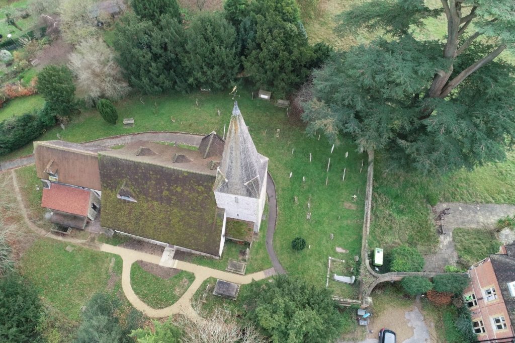
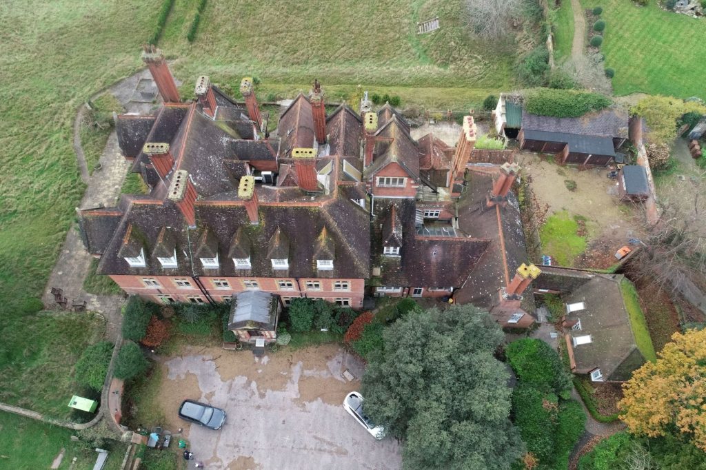
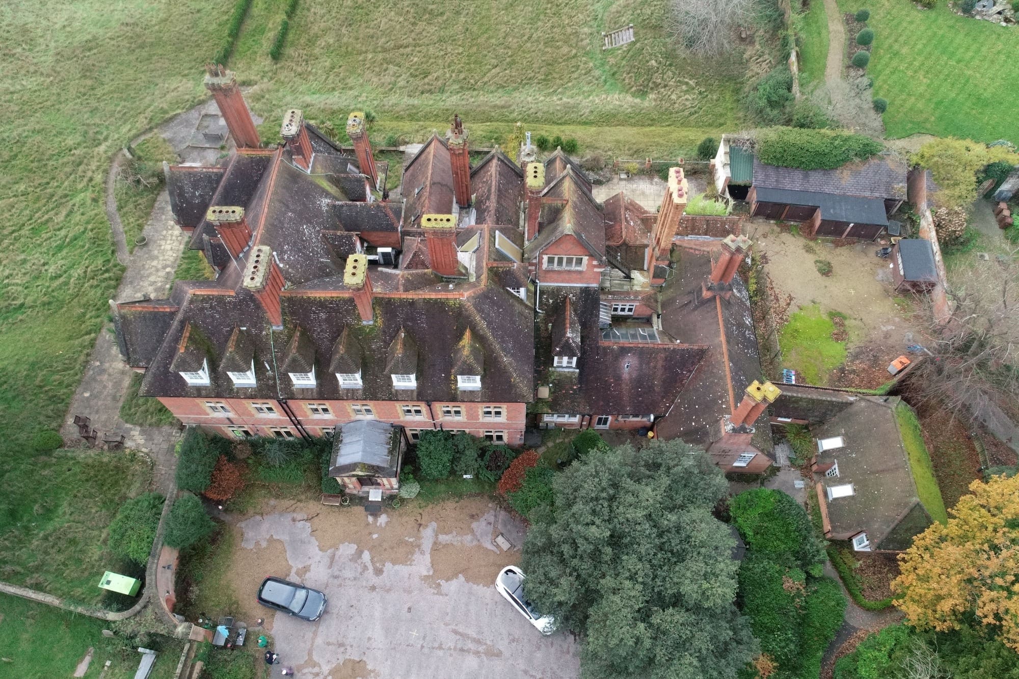
Drone inspections Oxford offer a secure and effective way to inspect roofs of any size and pitch. Drones can easily access areas hard to reach with traditional methods, which are often time consuming, capturing detailed aerial data and information of potential issues such as leaks, deteriorated shingles, or chimney stack problems. This allows for early detection of problems, ensuring the roof remains in good condition and preventing costly repairs down the line. Conducting a drone roof survey, a key part of our drone surveys Oxford offerings, provides high-resolution imagery and videos, enabling property owners to assess their roofs effectively and make informed decisions regarding maintenance or purchases. Our drone services excel here.
Building inspections using drones, a form of aerial survey, provide a secure and effective way to inspect building facades, identifying issues such as cracks, water damage, or structural problems to ensure the building is in good condition. This method is far less intrusive and time consuming than traditional methods, reducing the need for scaffolding or other access equipment. Drones can also be used for drone mapping to monitor construction progress, tracking material stockpiles, and providing valuable aerial data for project management and planning. These services, including drone surveys Oxford, are vital.
Drones play a critical role in infrastructure inspections, such as those offered through our drone inspections Oxford services. These drone surveys allow for the secure and effective inspection of bridges, pipelines, power lines, and other infrastructure. By identifying potential hazards and maintenance needs early on from the collected aerial data, drones contribute to preventative maintenance, helping to keep infrastructure in good condition and minimizing the risk of accidents. For instance, drone mapping with thermal imaging cameras can identify damaged or underperforming solar panels, ensuring efficient energy production. This is a core service for any site, far less time consuming than manual checks.
- How We Work
Who Can Benefit from Drone Surveys?
Gain valuable insights into the condition of your property, plan maintenance, and ensure risk reduction. These are practical benefits of drone services.
Monitor construction progress, track materials, and ensure quality control throughout the construction process. Our drone mapping helps you work smarter on your site.
Assess damage, verify claims, and reduce fraud with accurate aerial data and documentation. This is part of our services in the Oxfordshire area.
Collect precise data for planning and design purposes, improving effectiveness and reducing project durations. Our drone services provide this detail.
Showcase properties with stunning aerial views, attract buyers, and highlight key site features. This mapping is part of our drone services.
- Established Excellence in Surveying
How Cost Effective Are Drone Surveys?
The measured building survey cost for a drone survey, including services like drone mapping or a comprehensive aerial survey, varies depending on several factors, including the size and complexity of the site to be surveyed. Larger and more complex sites may necessitate more duration and resources, affecting the overall cost, though often still less time consuming and more cost-effective than traditional approaches. The specific type of inspection required, such as those offered by drone inspections Oxford, also plays a role, as different inspections may require specialized equipment or expertise. For example, a roof inspection to check its good condition may be less expensive than a detailed inspection of a large building element.
The level of aerial data processing and deliverables also influences the cost. Basic drone surveys Oxford may include just the raw images and videos, while more comprehensive surveys might involve detailed 3D models, orthomosaic maps, or other advanced deliverables. The location of the site can also be a factor, as travel expenses and local regulations may influence the final price. It is always advisable to contact a CAA approved drone company directly for a personalized, tailored quote based on your specific requirements.
What to Expect from a Drone Inspection
A drone inspection offers a modern, cost-effective solution for assessing the condition of buildings and elements. Here’s what you can expect from a drone inspection Oxford: a premier service in the Oxfordshire area
Equipped with high-resolution cameras and advanced sensors, drones capture detailed information and data, providing a comprehensive assessment of the building or structure. This thorough approach ensures that no detail is overlooked. These drones are essential for any site.
Drone inspections are adept at identifying various types of deterioration and defects, such as cracks, holes, and missing tiles. This precise identification allows for targeted repairs and maintenance, preventing minor issues from escalating into major problems. This is a core service of our drone services.
Over time, buildings and elements experience wear and tear. Drone inspections can effectively assess the overall condition, highlighting areas with faded or damaged materials. This information is crucial for planning maintenance and ensuring the longevity of the structure. Our drone services are reliable for any site in the UK.
Based on the findings, drone inspections Oxford provide actionable recommendations for maintenance and repairs. Whether it’s cleaning, repairing, or replacing components, these insights help in maintaining the integrity and risk reduction of the building or structure. These services are invaluable.
Drone inspections are a cost-effective alternative to traditional methods, reducing the need for manual inspections and minimizing risk factors. The efficiency of drones allows for quick data collection and insight generation, saving both duration and money. This service is key.
Benefits of Using Drones for Roof Inspections
- Cost-Effective: Drone surveys are often more affordable than traditional inspection methods, as they eliminate the need for expensive equipment and scaffolding. This leads to a reduced cost by minimizing expenses related to traditional setups and requiring fewer personnel. All our services aim for cost-effectiveness.
- Efficient: Drones can quickly cover large areas and access hard to reach areas, significantly reducing inspection duration. This is a vital service for any site.
- Safe: Drone inspections minimize the need for personnel to work at heights or in hazardous environments, enhancing risk reduction and reducing risks. Our services prioritize this.
- Detailed Data: Drones capture high-resolution images and videos, providing detailed information for accurate assessments and insight generation. This is a core service of our drone services.
- Minimal Disruption: Drone surveys can often be conducted with minimal disruption to ongoing operations or activities at the site. Our drones work quietly.
Applications of Drone Surveys
Drone surveys have revolutionized the way various industries conduct inspections and gather data. Their versatility and effectiveness make them invaluable tools for numerous applications: these services are top-tier in the UK
Roof Inspections
Drone inspections Oxford provide a secure and effective method to inspect roofs of all types, including flat roofs and those with steep pitches. By capturing detailed images of potential issues like leaks, deteriorated shingles, or chimney stack problems, drones help in early detection and prevention of costly repairs. This method minimizes risk factors by reducing the need for manual inspections at dangerous heights. This service is a specialty in the Oxfordshire area.
Building Inspections
Utilizing drones for building inspections allows for a comprehensive assessment of facades and elements. Drones can identify defects such as cracks, water damage, or structural issues without the need for intrusive scaffolding or access equipment. This not only saves duration but also ensures a thorough inspection, aiding in maintenance and risk reduction planning. This is a valuable service for any site.
Solar Panel Inspections
Drones equipped with thermal imaging cameras are particularly effective for inspecting solar panels. They can quickly identify damaged or underperforming panels, ensuring that solar installations operate at maximum efficiency. This proactive approach helps in maintaining energy production and reducing downtime. Our services contribute to work smarter initiatives for clients.
Aerial Mapping
Drone surveys are ideal for creating detailed maps of large areas, such as construction sites, farms, and forests. These maps provide valuable insights for planning and management, helping businesses and organizations make informed decisions based on accurate data. This mapping is a core service for any large site.
Disaster Response
In the aftermath of natural disasters, drone surveys can rapidly assess damage and identify areas in need of immediate attention. This capability is crucial for informing response and recovery efforts, ensuring that resources are allocated effectively and efficiently. Our services are critical in these scenarios.
- Established Excellence in Surveying
Drone Technology and Equipment
At Geocad, we utilize cutting-edge drone technology and survey equipment to ensure the highest quality data collection and results. Our drones are equipped with high-resolution cameras for capturing detailed images and videos, along with advanced sensors tailored for various types of inspections, including thermal imaging and LiDAR. Integrated GPS and navigation systems allow precise flight control and data geo-tagging, while sophisticated software streamlines data processing, insight generation and reporting. These drones are indispensable for any site.
We have successfully completed numerous drone survey projects for diverse clients, including roof inspections for homeowners and property managers, identifying leaks, damage, and other issues. Our services have also benefited construction companies through building inspections, assessing construction progress, quality, and risk mitigation, and local authorities utilizing our expertise for infrastructure inspections, monitoring bridges, roads, and other assets. Our drone services excel here.
We adhere to all relevant regulations and guidelines set forth by the Civil Aviation Authority (CAA) to ensure secure and legal drone operations. Our pilots are certified and experienced, and we prioritize risk reduction in every aspect of our work. Our drones comply fully.
Conclusion
Drone surveys and inspections are transforming the way industries conduct assessments and gather data. Their ability to capture high-resolution images and detailed information makes them invaluable for identifying damage, assessing wear and tear, and providing maintenance recommendations. Whether you’re a property owner, construction company, or government agency, drone surveys offer a cost-effective and efficient solution to make informed decisions and reduce costs. Embrace the future of inspections with drone technology and experience the benefits of enhanced risk reduction, accuracy, and effectiveness. Our drones lead the way.
Frequently Asked Questions (FAQs)
How much does a drone survey cost?
The cost of a drone survey depends on several factors, including the size and complexity of the site to be surveyed. Larger and more complex sites may necessitate more duration and resources, affecting the overall cost. The specific type of inspection required also plays a role, as different inspections may require specialized equipment or expertise. For example, a roof inspection may be less expensive than a detailed inspection of a large building element. The level of data processing and deliverables also influences the cost. Basic surveys may include just the raw images and videos, while more comprehensive surveys might involve detailed 3D models, orthomosaic maps, or other advanced deliverables. The location of the site can also be a factor, as travel expenses and local regulations may influence the final price. It is always advisable to contact a drone survey company directly for a personalized tailored quote based on your specific requirements. These services are tailored.
Is a drone survey safe?
Yes, drone surveys are secure when conducted by certified pilots following strict risk mitigation protocols and regulations. We prioritize risk reduction in every aspect of our work. Our drones maintain high safety.
What type of data can a drone survey provide?
Drones can capture high-resolution images, videos, thermal data, LiDAR data, and more, depending on the specific equipment used. We can tailor the data collection to your needs. These drones are versatile.
How do I choose a reputable drone survey company?
Look for companies with certified pilots, experience in your specific industry, positive client reviews, and a commitment to risk reduction and compliance. Geocad meets all these criteria and more. Our services are trusted.
Can drone surveys be used in any weather conditions?
Drone surveys are weather-dependent and cannot be conducted in heavy rain, strong winds, or other adverse conditions. We prioritize risk reduction and will reschedule if necessary. These drones operate optimally in good weather.
How long does a drone survey take?
The duration of a drone survey depends on the size and complexity of the area, the type of inspection, and other factors. We will provide you with an estimated timeframe during the consultation process. Our drones streamline the process.
What are the regulations for drone surveys?
Drone surveys are subject to regulations set forth by the Civil Aviation Authority (CAA). We adhere to all applicable laws and guidelines to ensure legal and secure operations. Our drones always comply.
What is a drone survey report?
A drone survey report is a comprehensive document that includes the captured data, insightful findings, and recommendations. We tailor the report to your specific needs and objectives. Our drone services provide this detailed report for your site. Our services include this detailed report.
Can drone surveys be used for emergency inspections?
Yes, drone surveys can be used for emergency inspections, such as assessing damage after a storm or other event. Contact us for immediate assistance. Our drones are ready for inspection anytime. These drone services are vital for any site.
How do I prepare for a drone survey?
We will provide you with detailed information on how to prepare for your drone technology survey, including any necessary site preparations or notifications. Our drone services make preparing for your site survey easy.
What if I have more questions?
We are always happy to answer your questions and provide further information. Feel free to contact us at any time. Our services are always available. We pride ourselves on offering comprehensive services for all our clients.


- Our Testimonial
Don't Just Take Our Word For It...
We believe that trust is earned. Here is what our clients say about their experiences working with GEOCAD and how our surveys have helped them.
We’re proud of the strong relationships we’ve built with our clients. See what they have to say about their experience working with us.
Carried out a measured survey on our complex listed building, which has not a single straight wall. He did a very professional job and both ourselves and our architects were impressed with the drawings he produced