Topographical Survey UK
In today’s rapidly evolving landscape, accurate land measurement is no longer a luxury – it’s a necessity. Whether you’re involved in construction, architecture, engineering, or property development, having precise spatial information about the terrain is paramount. A topographic survey provides this critical data, enabling informed decision-making, minimizing risks, and preventing costly errors.
Your Guide to Accurate Land Measurement
At Geocad, we specialize in delivering top-notch topographical survey works tailored to the specific needs of our clients. With our experienced team, cutting-edge technology, and unwavering commitment to accuracy, we empower you to achieve your project goals with confidence. We understand the importance of accurate data for construction projects, which is why we employ the latest technology and experienced land surveyors to deliver precise measurements.
Benefits And Solutions
Partnering with Geocad for your topographical survey needs unlocks a range of advantages that set us apart:
Precision and Accurate Data
We leverage state-of-the-art equipment and proven methodologies to guarantee the highest degree of accuracy in every measurement. Precise data is at the heart of everything we do.
Modern Technologies
We utilize cutting-edge technologies like laser scanning and drone surveys, enabling us to capture comprehensive data swiftly and efficiently, even for the most complex sites.
Experienced Team
Our team of seasoned land surveyors brings a wealth of experience and in-depth knowledge to every project, ensuring meticulous attention to detail and reliable results.
Tailored Approach
We recognize that every project is unique. We collaborate closely with you to understand your specific requirements and customize our services to meet your exact needs.

Service Inclusions
Our comprehensive topographical surveying services encompass all aspects of land measurement and analysis:
- Detailed terrain mapping
- Capturing both natural and man-made features
- Creation of accurate drawings
- Comprehensive documentation in CAD format
- In-depth data analysis
- Valuable insights for informed decision-making
- Professional consultations with our experienced team
- Ensuring you understand the data and its implications.
Get Quote
Our Services
- How We Work
Working Process
Engaging Geocad for your topographical survey needs is a smooth and transparent process:
01.
Initial Consultation
Initial contact and consultation to discuss your project objectives, timeline, and specific needs.
02.
Detailed quote
Provision of a detailed, no-obligation quote outlining the scope of work and associated costs.
03.
Measurement
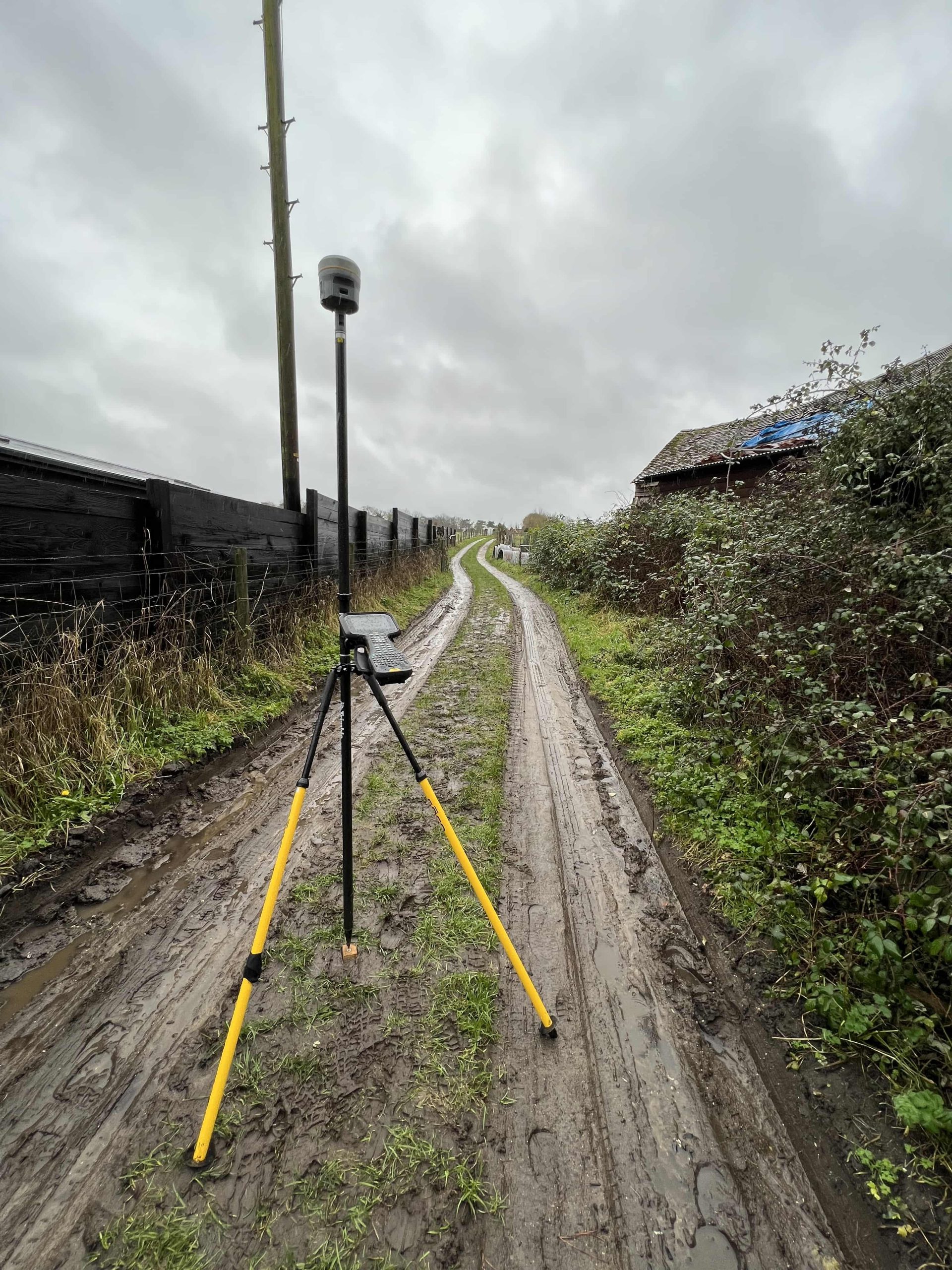
Conducting on-site measurements using highly specialised survey equipment, the most appropriate and advanced surveying techniques, including total stations, laser scanning, and drone surveys. This process includes establishing fixed points for precise referencing.
04.
Processing the data
Processing and analyzing the collected data, ensuring accuracy and reliability.
05.
Delivery & Support
Delivery of comprehensive and easy-to-understand results in your preferred CAD drawings format, empowering you to make informed decisions.
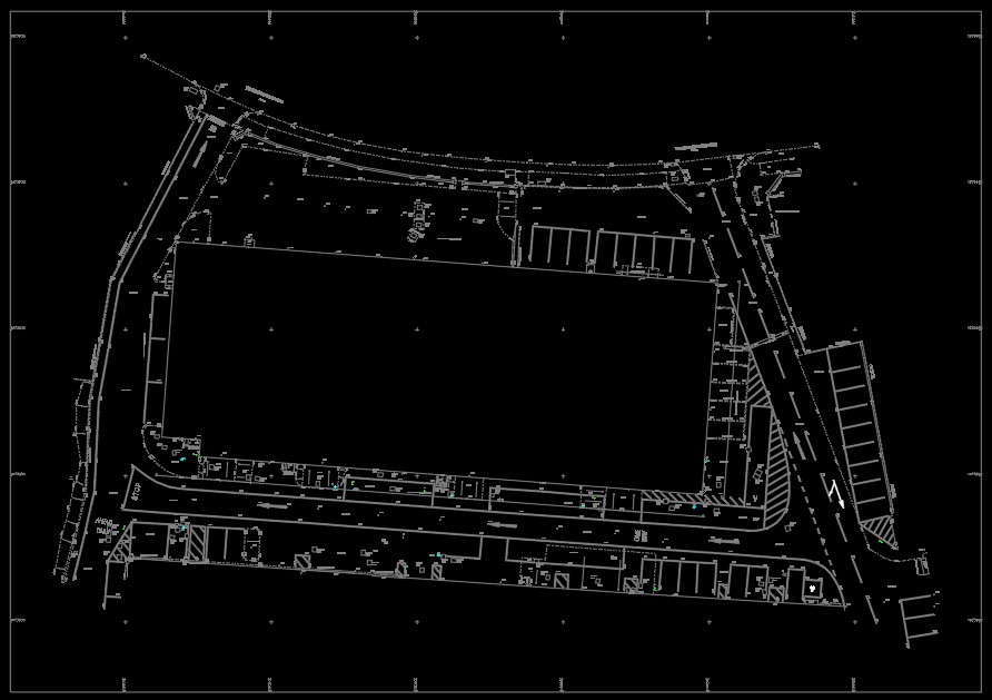
What is a Topographical Survey?
A land survey, specifically a topographical survey, is a meticulous assessment of an existing site, providing detailed information about its elevation, contours, and all relevant site features, both natural and man made. Terrain surveys are a crucial component of a topographic survey, providing detailed information about these typical elements. This survey data is absolutely critical for a broad range of purposes, enabling informed decision-making and preventing high-priced mistakes in construction, architecture, engineering, land development, and more. Precise details provide critical information for development projects, offering an accurate picture for planners and engineers.
Why Choose a Topographical Survey?
Those services are essential across various sectors:
- Construction Projects: Accurate land data, providing an accurate depiction of the site layout, is the cornerstone of successful construction projects throughout the construction phase. Obtaining information at an early stage through these surveys is vital. It enables precise planning, efficient design, accurate earthwork calculations, and effective project management, helping to reduce cost and prevent costly errors.
- Architecture and Design: Architects rely on topographic surveys to create designs that seamlessly integrate with the terrain, optimizing aesthetics and functionality for new buildings. Engineering: Engineers utilize topographical data for a multitude of projects, ensuring all survey requirements are met, particularly for designing infrastructure like drainage schemes and ensuring drainage ditches function properly.
- Engineering: Engineers utilize topographical data for a multitude of projects, ensuring all survey requirements are met.
- Land Owners: Landowners might need a topographic land survey for various reasons, such as the precise demarcation of site boundaries, obtaining planning permission, resolving land disputes to establish a defined boundary, or assessing the potential of their property for development, including complex brownfield sites. This often involves detailed assessment of an area of land to produce accurate site sections.
Our expertise in conducting surveys ensures that we provide reliable and accurate information essential for successful development projects in the city.
- Pricing
Topographical Survey Costs and Pricing
The cost of a topographic survey from our experienced land surveyors at Geocad can vary significantly based on several factors, including the complexity of the site, the size of the area of land to be surveyed, and the level of detail required regarding site features like existing boundaries and existing buildings. Obtaining correct information at an early stage about the site is crucial for any project, as it can significantly reduce cost by preventing later revisions and costly errors.
For projects requiring details for planning permission, detailing the site layout for a proposed site, or needing precise data referenced to the national grid system, our pricing is tailored. We understand that every project is unique and requires a bespoke survey to accommodate larger or more intricate requirements, ensuring you receive the precise level of detail and accuracy needed.
To discuss your project and receive a personalized, no-obligation quote that accurately reflects the scope and requirements of your topographical survey, please contact our team.
- Methods
Methods of Topographical Surveying
Topographical surveying utilizes a combination of traditional and modern methods:
01.
Traditional Techniques
These time-tested methods involve using instruments like levels, theodolites, and total stations for ground-based measurements. While reliable, they can be time-consuming.
Traditional Land Surveying Techniques
Traditional surveying techniques, while reliable and still relevant, can be more time-consuming and labor-intensive compared to modern methods. They are often suitable for smaller sites and projects with less complex terrain. Land surveyors are skilled in these techniques. Topo surveys have proven to be an invaluable tool for a wide variety of projects. Whether it’s a small residential development or a large-scale infrastructure project, these surveys provide essential information about the terrain, enabling informed decision-making and preventing high-priced mistakes.
02.
Modern Techniques
Advanced technologies like laser scanning and drone surveys offer greater efficiency and detail, capturing vast amounts of data quickly and accurately. These methods are ideal for large sites, complex terrain, and projects requiring highly detailed information.
Modern Topographical Surveying Techniques
Modern techniques like laser scanning and drone surveys provide unparalleled efficiency and detail, capturing extensive amounts of information rapidly and accurately about the existing site. Obtaining correct information early through these methods is essential for conducting a comprehensive topographic survey, providing detailed assessments of natural topographic features as well as man-made topographic features, including existing boundaries. These methods are particularly advantageous for larger development sites and projects that demand highly detailed information about these features. These techniques allow for the creation of accurate drawings and measured surveys. In addition to laser scanning, measured building surveys are another valuable tool for capturing detailed information about existing buildings. Measured building surveyors utilize a variety of techniques, including laser scanning and traditional methods, to create accurate representations of buildings, including floor plans, elevations, and sections.
The Benefits of Professional Topographical Surveys
Engaging professional surveyors for your topographical needs offers significant advantages:
Accuracy and Precision
Experienced surveyors employ rigorous techniques and advanced equipment to ensure the highest levels of accuracy and precision in their measurements, minimizing errors and expensive mistakes caused by inaccurate data.
Time-Saving and Efficiency
Outsourcing topographical surveys to professionals saves you valuable time and resources, allowing you to focus on other critical aspects of your project.
Cost-Effectiveness
Accurate land data can prevent costly mistakes, rework, and unforeseen issues during construction or development, ultimately saving you money in the long run.
Choosing the Right Topographical Survey Company
Selecting a reputable and experienced surveying company is crucial for obtaining reliable and accurate results:
Experience and Expertise
Look for a company with a proven track record, extensive experience in topographic land surveys, and a team of experienced surveyors.
Advanced Technology
Choose a company that utilizes the latest technology and equipment, such as laser scanners, drones, and total stations, to ensure accuracy, efficiency, and comprehensive data capture.
Client Satisfaction
Check for positive client feedback, testimonials, and case studies to gauge the company’s reputation and commitment to client satisfaction.
Understanding the Topographical Survey Process
A typical topographical survey follows a well-defined process:
- Planning: Defining the scope, objectives, and specific client requirements of the survey.
- Data Collection: Employing a variety of techniques, including traditional methods and modern technologies like laser scanning, to gather accurate measurements of land features.
- Data Processing: Analyzing and interpreting the collected exact data to create comprehensive maps, drawings, and reports.
- Reporting: Presenting the survey results in clear, understandable formats, such as CAD files, maps, and digital models.
Applications of Topographical Surveys
It has a wide range of applications:
Construction Projects
From initial site planning and design to earthwork calculations and construction management, accurate topographic survey are indispensable for successful project execution.
Architects and Designers
Accurate land data empowers architects to create designs that harmonize with the surrounding environment, optimizing aesthetics, functionality, and sustainability.
Land Development
Developers rely on topographic survey to assess the potential of land, plan infrastructure, and maximize the value of their projects.
Planning Applications
This service is often a mandatory requirement for planning applications, providing local authorities with the necessary information to assess proposed developments. Topographical land surveys are often required by the land registry to ensure accurate property boundaries and land ownership information.
Topographical Survey Regulations and Standards
Topographical surveys are governed by a range of regulations and standards designed to ensure accuracy, reliability, and consistency. At Geocad, we adhere to these stringent guidelines to deliver topographical surveys that meet the highest industry standards.
Our land surveys comply with the Royal Institution of Chartered Surveyors (RICS) guidelines for topographic surveys, ensuring that our methods and practices are aligned with industry best practices. Additionally, we follow the British Standard for topographic survey (BS 7913:2013), which provides a framework for conducting surveys with precision and reliability using high-quality survey equipment.
We also adhere to the Construction Industry Council (CIC) guidelines for topographic survey, which outline the necessary procedures and standards for conducting accurate and comprehensive surveys of site features. By following these regulations and employing accurate GPS equipment, we ensure that our land survey provides the reliable data needed for successful construction projects, land development, and property management.
This commitment to excellence ensures that our topographic survey is not only accurate but also meets the specific needs of our clients, offering tangible practical benefits. By leveraging advanced technologies like laser scanning equipment and mobile mapping, we can work more efficiently, helping to save considerable time in data acquisition and processing. Whether you are planning a construction project, submitting a planning application, or assessing land for development, you can trust Geocad to deliver topographic surveys that adhere to all relevant regulations and standards and utilise the latest technology for optimal results.
Our topographical surveyors are trained to the highest standards and equipped with the latest technology and equipment.
- FAQ
Frequently Asked Questions (FAQs)
Here are answers to some frequently asked questions about topographic survey:
How much does a topographical survey cost in the UK?
The topographic survey cost in the UK varies depending on several factors, including the size and complexity of the site, the location, the required level of detail, and the chosen survey methods. Contact us for a free quote tailored to your specific needs.
What is a topographical survey for?
It serves a multitude of purposes, from providing essential data for construction and architectural design to supporting land development, planning applications, and property management. They are also critical for utility surveys, identifying underground utilities, and understanding the relationship between existing infrastructure and proposed development. Understanding where underground utilities are located is crucial during the development process to avoid costly mistakes and potential hazards.
How long does a topographical survey take?
The duration of a topographical survey depends on the size and complexity of the site, the chosen survey methods, and the specific client requirements. We strive to complete surveys efficiently and within agreed-upon timelines.
How accurate is a topographical survey?
Professional land surveyors employ rigorous techniques and advanced equipment to ensure the highest levels of accuracy in their measurements. We are committed to delivering precise and reliable data.


- Our Testimonial
Don't Just Take Our Word For It...
We believe that trust is earned. Here is what our clients say about their experiences working with GEOCAD and how our surveys have helped them.
We’re proud of the strong relationships we’ve built with our clients. See what they have to say about their experience working with us.
Carried out a measured survey on our complex listed building, which has not a single straight wall. He did a very professional job and both ourselves and our architects were impressed with the drawings he produced